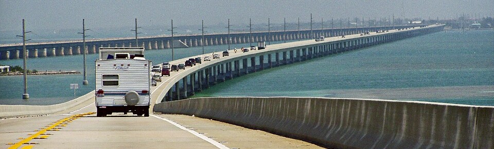
Seven Mile Bridge — Florida Keys Visitor Guide
Address: Seven Mile Bridge, Florida, United States • Location: Knights Key ↔ Little Duck Key • Route: Overseas Highway (US‑1)
Why the Seven Mile Bridge is a must‑see
The Seven Mile Bridge is the signature drive of the Florida Keys — a ribbon of concrete and sky that carries US‑1 over the turquoise waters of the Gulf of Mexico and the Atlantic Ocean. Spanning the gap between Knights Key at Marathon and Little Duck Key on the Lower Keys, the bridge has long symbolized the Keys’ spirit of connection: a place where engineering ambition meets island calm. Whether you’re road‑tripping to Key West, chasing sunrise and sunset photos, or simply curious about one of America’s most recognizable bridges, this page gathers everything you need for a smooth, safe, and memorable visit.
- Total length: 10,888 m (≈ 6.76 mi)
- Bridge type: Box girder bridge
- Vertical clearance: ~20 m
- Construction began: 1978 • Opened: May 24, 1982
- Part of: Overseas Highway (Keys), the southern stretch of the 2,369‑mile US‑1
- Historic note: Early Keys development was propelled by Henry Flagler’s vision and his Overseas Railway legacy.
Plan your visit at a glance
Getting there
Most visitors approach from Miami via US‑1 through Key Largo and Islamorada, or from the south via Key West. The bridge itself is part of the highway — you simply drive across it in the normal flow of traffic. See How to Get There for detailed directions, approximate driving times, and suggested scenic stops.
Parking & pull‑offs
There is no general‑use parking on the active bridge span. Instead, look for designated pull‑offs and parks on either side of the bridge, as well as parking areas near nearby attractions such as scenic viewpoints and beaches. Respect all posted signs and never stop on the bridge shoulder unless directed by law enforcement or in an emergency.
Pedestrians & cyclists
The modern vehicular bridge is designed for motor traffic. Pedestrian access is commonly associated with dedicated recreation segments on the Old Seven Mile alignment and nearby pathways where open. Always confirm current access rules before planning a walk or ride and use only designated recreational areas.
Fees & hours
The highway is open year‑round and there is no toll to drive across the Seven Mile Bridge. Weather, maintenance, or special events can affect conditions; check local advisories if storms are forecast.
Best time to visit
The bridge is striking in any season, but conditions change with the Keys’ tropical climate. Winter and early spring often bring the clearest air and gentler temperatures — superb for long‑view photography. Late spring into summer delivers intense blues and greens in the water and dramatic cloudscapes, with higher humidity and the chance of afternoon showers. Late summer and early autumn align with the Atlantic hurricane season; if you visit then, monitor forecasts closely and build flexibility into your plans.
For photographers, sunrise and sunset are the magic windows. At sunrise, winds are often lighter and the colors more pastel; at sunset, golden light rakes across the deck and side spans. Weekdays outside of holiday periods generally bring steadier traffic flow and easier stops at nearby overlooks.
What to see & do near the bridge
- Scenic driving: Take in unbroken horizons, island silhouettes, and the sensation of “driving on the sea.”
- Photography: Capture side‑profiles of the bridge from legal vantage points on shore; telephoto lenses flatten the spans into iconic arcs, while wide‑angles emphasize sky and water.
- Beaches & parks: Plan short breaks at nearby day‑use parks and viewpoints. Bring sun protection and water.
- Fishing & boating: Charter trips and public piers are available in the Middle and Lower Keys. Follow all local regulations; never fish from the active vehicular bridge.
- Wildlife watching: Look for seabirds, rays in shallow flats, and the occasional dolphin offshore from safe, designated viewpoints.
Brief history
The Seven Mile name recalls a storied lineage. Early 20th‑century Keys infrastructure grew from Henry Flagler’s bold vision to link the islands with rails and viaducts — a feat that transformed travel and settlement. Decades later, a modern engineering answer was needed for higher traffic volumes and improved safety, and the present box‑girder span took shape between 1978 and 1982. Today’s bridge is both practical artery and coastal landmark, balancing function with the panoramic drama that has made the Overseas Highway one of America’s great road trips.
Nearby attractions & logical stops
- Marathon (Knights Key side): Services, fuel, restaurants, charters, and lodging central to exploring the Middle Keys.
- Lower Keys (Little Duck Key side): Gateway to a string of quieter islands and natural areas on the way to Key West.
- Scenic overlooks & beaches: Use signed turnouts and designated recreation areas for bridge views, beach time, and picnics.
- Key West (day trip or overnight): Historic streets, sunset at Mallory Square, and classic Conch architecture at the end of US‑1.
Build a flexible itinerary that mixes short stops for photos with longer pauses for food, beach time, or a charter excursion. Distances are modest, but traffic can be steady on weekends and holidays.
Safety & road etiquette
- Stay in motion on the bridge: Do not stop on the shoulder for photos — plan pull‑offs before or after the span.
- Mind the wind: Crosswinds can be notable. Keep both hands on the wheel and avoid distractions.
- Watch weather windows: Summer squalls pass quickly, but heavy rain can reduce visibility. Use headlights and increase following distance.
- Share the road: Expect RVs and trailers; allow extra time and pass only where legal.
- Sun & hydration: The Keys’ sun is intense year‑round. Sunscreen, hats, and water are essentials whenever you leave the vehicle.
Photo tips (simple, proven)
- Scout from shore: Side profiles from legal viewpoints show the bridge’s repeating spans against open water.
- Shoot early/late: Low angles of light add texture to the deck and railings; clouds catch color after sunset.
- Use a polarizer: It cuts glare and deepens the Keys’ blues and greens.
- Tell a scale story: Include vehicles or islands to convey the bridge’s length.
- Respect boundaries: Never step onto restricted areas for a shot — the views from designated spots are excellent.
Seven Mile Bridge — FAQ
Is there a toll?
No, there is no toll to drive the Seven Mile Bridge on US‑1.
How long does it take to cross?
Under normal flow, the crossing itself takes about 10–15 minutes. Allow more time on weekends and holidays.
Can I walk or bike on the bridge?
The active vehicular bridge is not a pedestrian promenade. Recreational access is associated with signed areas and legacy segments where open. Always follow posted guidance and check current conditions loc